An Intro to Whitewater Rapids Classes

Whitewater Rafting on the Lower Deschutes - Imperial River Company

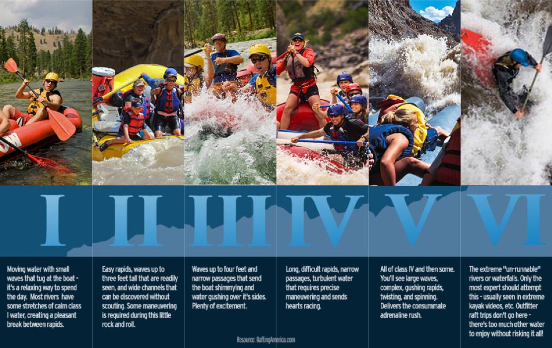
Just like your teacher used to grade your tests in school, whitewater (either an individual rapid, or the entire river) is graded too! Instead of A to F, these grades are divided into six categories from class I (the easiest) to class VI (the most difficult and dangerous).

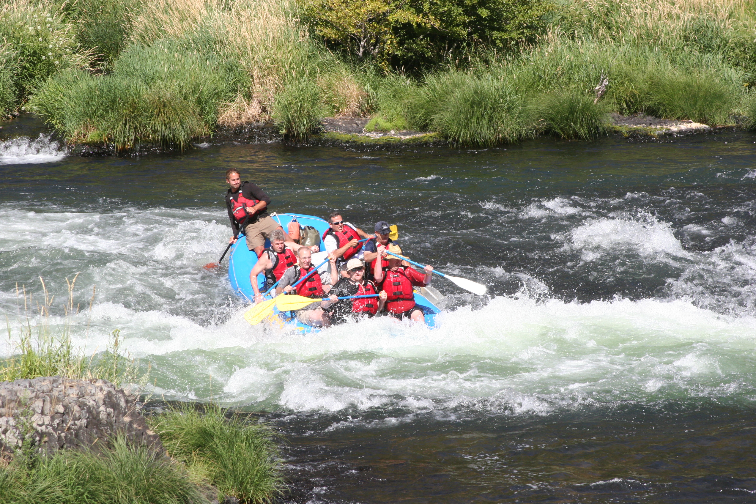
As the White Water Guidebook explains, the Deschutes River runs hundreds of miles from the mountains near Bend, Oregon to the Columbia River. The river is runnable for its entire length offering rapids from Class I to VI, great fishing, and overnight trip options. The most popular section of the Deschutes is from Harpham Flat to Sandy Beach and runs through the town of Maupin, hence the location of the Imperial River Company! The fun rapids and consistent flow make it a great place to raft on a hot summer day.

Rapids Classes Defined:

Class I

Moving water with a few riffles and small waves – it’s a relaxing way to spend the day.

Class II

Easy rapids, waves up to three feet tall that are readily seen, and wide channels that can be discovered without scouting. Some maneuvering is required during this little rock and roll. Examples during our Deschutes day trip:

    • Mile 34.2: Four Chutes Rapids – wave train down the left, boulder garden on the right.
    • Mile 49.9: Surf City Rapids (II+) – offers paddlers a chance to work on their surfing.
    • Mile 51.1: White River Rapids (II+) – fun waves at the White River confluence.
    • Mile 51.8: Lower Elevator Rapids(II+) – multiple waves for excitement and light splashing.

Class III

Moderate – Waves numerous, high, irregular; rocks; eddies; rapids with passages clear but narrow, requiring experience in maneuvering. Waves up to four feet that send the boat shimmying and water gushing over its sides. Plenty of excitement.

      • Mile 21.1: White Horse Rapid (III+) challenging ½ mile boulder garden, action packed!
      • Mile 33.5: Buckskin Mary Rapids – a swift wave train down the middle.
      • Mile 42.9: Wapanita Rapids – thrilling wave train straight through the center.
      • Mile 44.0: Boxcar Rapids – large waves and a small ledge drop with a hole to the left that is best avoided.

Class IV

Long, difficult rapids, narrow passages, turbulent water that requires precise maneuvering and sends hearts racing.

    • Mile 50.3: Oak Springs Rapids – A big drop with routes down the right or left. It’s an easy scout from the road on river right.

Class V

Extremely Difficult – Exceedingly difficult, long and violent rapids, following each other almost without interruption; riverbed extremely obstructed; big drops; violent currents; very steep gradient. Paddlers should have prior Class IV or better whitewater experience with experienced guides who know the river.

Class VI

Unrunnable! Just like it says – Don’t even think about it! These constitute waterfalls that should not be attempted. Outfitter raft trips don’t go here – there’s too much other water to enjoy without risking it all!

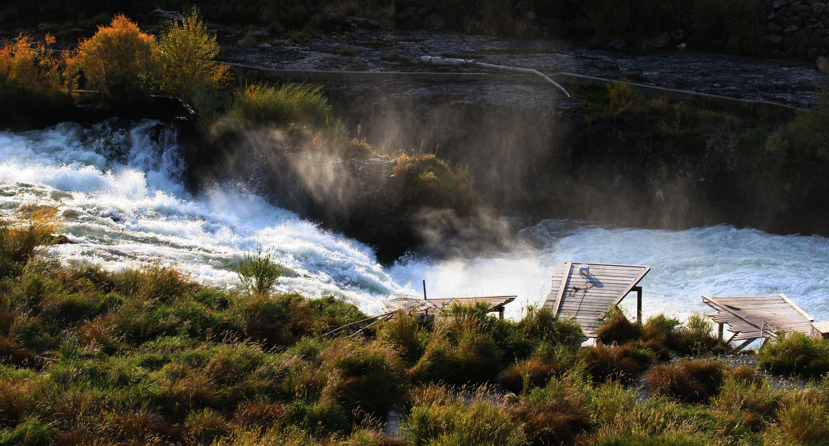
    • Mile 53.8: Sherars Falls, but we exit at Sandy Beach a mile before the falls.
Whitewater Rapids Classes - Deschutes River - Imperial River Co.
Image from RaftingAmerica.com

Now that you’re an expert on white water classification, check out this great breakdown of the Deshutes River Rapids from Harpham Flats to Sandy Beach so you know exactly what to expect at each turn.

Our runs range from class I to class III, with the option of a class IV for the more experienced rafters/thrill-seekers. With our experienced guides you get all of excitement with none of the none of the stress. We’ll see you out there!

Booking a rafting adventure here: https://deschutesriver.com/deschutes-river-rafting/  

Imperial River Company
Lodging and Rafting on the Lower Deschutes River
www.deschutesriver.com
irc@deschutesriver.com
(541)395-2404


You Don’t Know Deschutes

Deschutes River History-Imperial River Company

The Deschutes River is Maupin’s lifeblood, bringing fishing, recreation, jobs, and irrigation to the town and surrounding areas. The river has a long and rich history and many interesting features that make it unique. Check out some fun river facts below and impress your friends at trivia night.

A River by Any Other Name

The Deschutes River may have a bit of an identity complex. The Nez Perce tribe named the river ‘Towarnehiooks’ (translation: ‘enemies’) because a warring tribe, the Paiutes, lived along its banks. Part of the Lewis and Clark expedition recorded the Towarnehiooks name on their first encounter in 1805, then attempted to rename it the Clark River on their return in 1806. That name didn’t last long however, as early 19th century French fur traders dubbed the waterway the catchier ‘Riviere des Chutes’, which means ‘River of the Falls’, later dubbed the Deschutes.

Going with the Flow

The Deschutes River originates at Little Lava Lake in the Deschutes National Forest. Rainfall on the eastern side of the Cascade Range flows north down the Deschutes River to its mouth at the mighty Columbia River.  While most rivers cut their own path, the Deschutes had a much more dramatic and sudden change. It originally flowed around Pilot Butte in Bend from the east. Approximately 188,000 years ago, a lava flow filled in that channel during a period of volcanic activity in the area and the river was diverted into a new channel along the west side where it runs today.

The Other 98%

The high desert plateaus of Eastern Oregon are arid and rainfall averages between 10 and 14 inches per year (the national average is 38 inches per year). The Deschutes River allows cities to grow and enables ranching and agriculture to proliferate in the otherwise inhospitable environment. But desert living comes at a cost: during the summer months, nearly 98% of the river’s volume is diverted to irrigation channels.

As we head in to our summer season, we are thankful for the beautiful river that allows our city to flourish in this stunning landscape. We hope you’ll join us to celebrate life on the Deschutes and to take advantage of the many recreational opportunities in and around Maupin.

Imperial River Company
Lodging and Rafting on the Lower Deschutes River
www.deschutesriver.com
irc@deschutesriver.com
(541)395-2404

“SUP” With That? An Intro to Stand Up Paddle Boarding 

SUP in Maupin - Pine Hollow Paddle, X-Dog Events

A Brief History of SUP

Stand up paddle boarding, or SUP (“the act of propelling oneself on a floating platform with the help of a paddle or pole”), is the world’s newest water-sport craze. There is evidence, however, of early forms of SUP dating back over 3,000 years and spanning the globe from Peru, China, Israel, and beyond. Modern SUP can trace its early origins to 1960s Hawaii and the Waikiki Beach Boys of Oahu, and pro-surfer Laird Hamilton laid the groundwork for the sport with a well-documented SUP outing on September 12, 2002.

Over the last 17 years, the sport has exploded in popularity and there have been huge advances in equipment and materials design. Today, SUP-based activities include racing, yoga, touring and fishing. There are dozens of board rental companies and guides across the state of Oregon and plenty of social media groups and pages dedicated to sharing best practices and tips on optimal SUP locations around the globe.

SUP in Maupin

The Maupin area is a top choice for SUP aficionados due to the range of water conditions and our sunny, high-desert climate. Pine Hollow Reservoir in nearby Wamic, Oregon is a beautiful flat-water option for newbies to the sport. The Lower Deschutes River offers some calm stretches with slow-moving currents that are great for those with a little more experience. Expert SUPers can tackle the rapids along the Deschutes for an added challenge. Plus, if you want some extra company, you can bring your best fuzzy friend along for the ride.

One of our favorite SUP events is the X-Dog Events’ Pine Hollow Paddle, which takes place on the first Saturday in June. There are five different race events and a celebratory ‘paddle parade’ at the end of the racing day. This event truly is fun for the whole family and beginners are encouraged to participate!

Helpful SUP Information

  • SUP For Beginners:  REI has a series of articles detailing all that beginners need to know to get started with SUP.
  • Class & Rentals (Portland): Travel Portland’s list of SUP classes, SUP yoga, and where to get geared-up in and around the City of Roses.
  • SUP in the City: Travel Oregon serves up some of the best SUP sites across the state.

Stand up paddle boarding is a great workout and a fun group activity. With so many places to splash around, why not make this summer your summer of SUP?

Imperial River Company, Maupin OR
Lodging and Rafting on the Lower Deschutes River
https://deschutesriver.com/
irc@deschutesriver.com
(541) 395-2404

Photo: X-Dog Events, Pine Hollow Paddle 

Celebrating Oregon’s Scenic Bikeways Program

Map Oregon Cycling Routes

2019 marks the 10-year anniversary of the Oregon Scenic Bikeways program. The program currently boasts 17 routes, each one vetted by agency personnel for being not only beautiful, but also safe for cyclists and that add value to small rural communities throughout the state. If you’re looking for a true Oregon experience – look no further!

About the Program

Oregon has long been known for being a bike-friendly state, so it’s no surprise that we are the first (and, so far, only) state to designate a Scenic Bikeways Program. It was founded through a partnership between the Oregon Parks and Recreation Department, Travel Oregon, Oregon Department of Transportation and Cycle Oregon and is run by the Oregon Parks and Recreation Department.

New routes are proposed by local cyclists. Each route must include locations where cyclists can find support services such as water, restaurants, hotels and camping options. Only about half of the routes qualify but, for those that do, the rural communities benefit from promotional and state support. 

Economic Impact

A 2014 study on the economic impact of this program estimated that the routes contributed $12.4M in spending activity to the state during the calendar year. This figure represented about 3% of all bicycle-related tourism for the year, including both day trips and overnight adventures. As there were only 12 designated routes in 2014, that’s an average of $1M per route per year. If that estimate holds true, 2019 should see an economic benefit of at least $17M!

Planning Your Ride

The bikeways offer a wide variety of experiences. From easy, flat rides to high-intensity, multi-day treks, flat high desert prairies to forested hills, riders of all experience levels are sure to find a route (or several!) that is just right for them.

There are many resources for planning your Oregon Scenic Bikeway trip. Travel Oregon lists each route and includes photos, trip planning tips, and information on length, difficulty, and the best time of year to experience each route. Here, you’ll also find videos and tips on other sightseeing opportunities and activities to experience when you’re in the area.

The Oregon Parks and Recreation Department also has information on the routes that are organized by difficulty: Mild, Moderate, Challenging and Extreme. The page links to road conditions and construction information, ride with GPS links, and cue sheets. Check out the brochure and map for easy reference on-the-go.

You can also get inspired by taking a sneak peak of every route thanks to the Travel Oregon YouTube Channel’s Oregon Scenic Bikeways Playlist. (Imperial River Company is featured in the Sherar’s Falls video!)

This unique cycling tourism program is a fantastic addition to Oregon’s adventure-travel options and is certainly worth celebrating.

Imperial River Company, Maupin OR
Lodging and Rafting on the Lower Deschutes River
https://deschutesriver.com/
irc@deschutesriver.com
(541) 395-2404

Top 5 Oregon Bike Rides

Top 5 Oregon Bike Rides

Oregon is full of scenic routes for cyclists, ranging from wide-open high desert to dense and lush forests, snow-capped mountain peaks to the rocky coastline. We’ve picked our top five rides in Oregon for you to enjoy.

Sherar’s Falls Scenic Bikeway

The landscape around the Lower Deschutes River is spectacular, and the Sherar’s Falls Scenic Bikeway should be at the top of your list to ride this season. This 33-mile loop shows off the best of the high desert, with views of the raging Deschutes River, towering Mt. Hood, and seemingly endless plateaus of wheat fields and natural high desert terrain. Keep an eye out for mule deer, pheasant, and big horn sheep. If you’re a serious cyclist, you might consider entering the Deschutes River Valley Time Trial Stage Race, which takes place the last weekend in April each year.

Madras Mountain Views Scenic Bikeway

While you’re in Maupin, zip over to Madras for another Central Oregon Scenic Bikeway experience. This 30-mile loop offers amazing views of Oregon’s volcanoes and agricultural and pastoral scenery. On this route, riders will pass through the towns of Culver, Metolius and Madras. Each location offers a variety of amenities, including food, water and sanitary facilities. Look for Mt. Jefferson, Mt. Hood, the Three Sisters and other beautiful snow-capped peaks. Riders cruise on a smooth, paved road with several gravel overlooks above The Cove Palisades State Park and Lake Billy Chinook. These overlooks are great places to see eagles, raptors, deer and even snakes or lizards.  Madras offers some great lodging options so you can stay in the area a bit longer.  Madras Mountain Views Scenic Bikeway is a sure bet in Central Oregon.

Historic Columbia River Highway State Trail

Built in 1916, some call the Historic Columbia River Highway the most beautiful highway in the world. What used to be the main driving route across the top of Oregon is now a pedestrian and bike-only 38-mile path that winds along the stunning Columbia River Gorge to show off views of the river, cascading waterfalls, and quiet moss-covered forests. Most people ride the portion between Hood River and The Dalles where there is a paved bike-pedestrian connection. Start at the Columbia Gorge Discovery Center and take off through the Mosier Twin Tunnels for a bike route that starts in the high desert and ends in lush, dense forest.

Willamette Valley Scenic Bikeway

For a low-traffic route and valley views, try the Willamette Valley Scenic Bikeway. The route starts at Champoeg State Park and wanders for 130 miles. You’ll see the serene Willamette River, Willamette Mission State Park, and several historic buildings. There are plenty of places to stop along the way in the quaint towns that dot the trail, including Independence, Coburg, and Brownsville. This route is actually Oregon’s first Scenic Bikeway and it’s been a favorite route of cyclists for over a hundred years.

Rim Drive at Crater Lake

If you’ll be biking in Southern Oregon, you’ll want to complete the Rim Drive loop at Crater Lake. You’ll enjoy 33 miles of volcanic crater views as you navigate around the circumference of the lake. The loop is at 7,000 feet above sea level and has several tough hills, but there are ample scenic overlooks along the way to stop, rest, and take in the views. Although Crater Lake is a bit remote, you can start and stop your ride at the historic Crater Lake Lodge where you’ll find food, souvenirs, and a bed for the night if your ride tires you out.

No matter where in Oregon you choose to cycle, you’re sure to have an unforgettable experience.


Imperial River Company, Maupin OR
Lodging and Rafting on the Lower Deschutes River
https://deschutesriver.com/
irc@deschutesriver.com
(541) 395-2404


4 Stunning Spring Wildflower Hikes in Central Oregon

Best Spring Hikes in Oregon

Spring is a fantastic season for hiking and exploring the unique and beautiful landscape of Central and Eastern Oregon. The high desert climate of the Maupin area means that it’s often sunny and dry here, when our neighbors to the west are cloudy and soggy. Plus, the wide-open expanses are home to bright wildflowers (learn all about them in the Deschutes Land Trust’s Wildflower Guide), a plethora of birds, and other Instagram-worthy flora and fauna. Located just 2 hours from Portland, these hikes will make you feel like you’re a world away – without the jet lag.

Here are a few of our favorite wildflower hikes near Maupin:

1. Criterion Ranch: Exceptional Views

About 10 miles south of Maupin, Oregon, along U.S. 197, lies a tract of land owned by the Bureau of Land Management. Terry Richard of The Oregonian says the old Criterion Ranch may seem forlorn but actually provides sweeping vistas where hikers can enjoy watching wildflowers bloom in the spring. While it would be an easy walk down into the Deschutes River canyon below, climbing 2,000 feet for a return trip might not be so relaxing. Another option is to hike along the rim and make use of the plentiful rock outcroppings when you take a break to appreciate the gorgeous panoramic views of hills and rivers. This five-mile trek through a sage-covered old homestead is something even less experienced hikers will be able to appreciate.

2. Deschutes River Recreation Area: Three Trails in One

Visitors to the Deschutes River Recreation Area happily hike along the Atiyeh Deschutes River Trail, which runs parallel to the water. Fishermen, mountain bikers, and horseback riders similarly can’t resist this 3.5-mile trail that leads wilderness travelers into Gordon Canyon. For those seeking a more challenging hike, the Ferry Springs Trail runs along an abandoned railroad bed and extends nearly 17 miles upriver. In between Ferry Springs and Atiyeh is the Middle Trail. Savvy hikers enjoy following Ferry Springs until it crosses the Middle Trail, then following the Middle Trail back for a pleasurable 4.5-mile loop. Portland Hikers Field Guide offers a more detailed overview of the Deschutes River Recreation Area.

3. Macks Canyon: A Challenge for Hikers

Macks Canyon is an archeological site where a large prehistoric village once overlooked the Deschutes River. According to the BLM website, “[t]he site is characterized by shallow, circular, semi-subterranean house depressions, surface artifacts, and riverine shell deposits.” Starting from the north end of theMacks Canyon campground, hikers pass the signs forbidding motorized vehicles and head into four miles of rough terrain that take them to a series of sites where railroad trestles once crossed desert canyons. Each of the six trestle locations will require hiking into and out of the canyon, but the roughest stretches of trail can be avoided by staying on the river side of the railroad grade. When outdoor adventurers climb out of the last stretch of canyon, the trail smooths out for 7.4 relatively-easy miles and stunning vistas.

4. Maupin, Oregon: A Great Base for Hiking Adventure

With so many beautiful hiking options in the Maupin area, you’ll probably want to make a whole weekend of it. Contact the Imperial River Company to book accommodations for your next hiking trip along the beautiful Deschutes River.


Imperial River Company, Maupin OR
Lodging and Rafting on the Lower Deschutes River
https://deschutesriver.com/
irc@deschutesriver.com